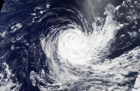
The Moderate Resolution Imaging Spectroradiometer or MODIS instrument aboard NASA's Terra satellite provided a visible image of Cebile on Feb. 6 at 4 a.m. EST (0900 UTC). The image showed the bulk of clouds and thunderstorms were being sheared to the southwest of the center, however a band of thunderstorms wrapped around a well-defined center of circulation.
At 10 a.m. EST (1500 UTC) on Feb. 6, the center of Tropical Cyclone Cebile was located near 26.3 degrees south and 81.7 degrees east, about 1,475 nautical miles east-southeast of La Reunion. The storm was moving toward the south at 7 mph (6 knots/11 kph) and is forecast to turn to the west. Maximum sustained winds are near 46.6 mph (40 knots/74 kph) making it a tropical storm.
Read more at NASA/Goddard Space Flight Center
Image: NASA's Aqua satellite provided a visible image of Tropical Cyclone Cebile on Feb. 5 at 3:25 a.m. EST (0925 UTC). The image showed the bulk of clouds and thunderstorms were being sheared to the southeast of the center. (Credit: NASA/NRL)


