On Feb. 8 when Gita formed and was drenching Samoa, the GPM core observatory satellite passed above at 9:26 a.m. EST (1426 UTC). Data collected by GPM's Microwave Imager (GMI) and Dual-Frequency Precipitation Radar (DPR) instruments showed the area and intensity of precipitation associated with the tropical cyclone. GPM, a joint satellite mission between NASA and the Japan Aerospace Exploration Agency, found that Gita was producing heavy rainfall over a large area that included the islands.
At the time, the center of the intensifying tropical cyclone was located just to the south of the islands. Rainfall measured by GPM's radar was falling at a rate of over 64 mm (2.5 inches) per hour. The heaviest rainfall was found by GPM in bands wrapping around the eastern side of Gita Rain in one of those downpours northeast of Samoa was found falling at a rate of greater than 224 mm (8.8 inches) per hour.
Read more at NASA/Goddard Space Flight Center
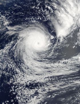
Image: On Feb. 11 at 4:35 p.m. EST (21:35 UTC) NASA's Terra satellite captured this visible image of Tropical Cyclone Gita in the South Pacific Ocean that revealed the storm had developed an eye. (Credit: NASA Goddard MODIS Rapid Response Team)