Environmental scientists at the U.S. Department of Energy’s (DOE) Brookhaven National Laboratory have led an international collaboration to improve satellite observations of tropical forests.
Responsible for nearly one-third of the world’s terrestrial photosynthesis, tropical forests are a critical biome for examining climate change and its potential impacts across the Earth.
“If we can improve our understanding of how much carbon dioxide (CO2) is absorbed by tropical regions, we can improve future climate projections,” said Jin Wu, a scientist at Brookhaven’s Environmental & Climate Sciences Department.
Satellite images are one of the most common tools scientists use to observe tropical forests, but the efficacy of the method has been a subject of debate. Some researchers have argued that seasonal changes in the “greenness” of tropical forests, as satellites have recently shown, could be misleading. Now, the collaboration led by Brookhaven has used field observations and computational models to help clear up the controversy. Their results, published on Feb. 6 in New Phytologist, also shed light on biological processes that have changed scientists’ understanding of seasonality in tropical forests.
Read more at DOE/Brookhaven National Laboratory
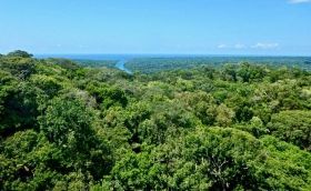
Image: A view of San Lorenzo, Peru, where Brookhaven scientists conducted field observations in the Amazon. (Credit: Brookhaven National Laboratory)


