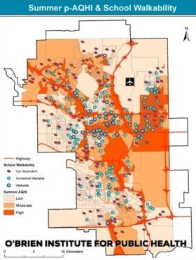
A University of Calgary study of seasonal air pollution will be of cold comfort to thousands of Calgarians living south of the Bow River: that crisp, wintry air they’re breathing in is the worst in the city.
The analysis, conducted by Stefania Bertazzon and Rizwan Shahid of the Geography of Health and GIS Analysis research group at the O'Brien Institute for Public Health in the Cumming School of Medicine, sheds new light on air quality variations and the potential impact on schoolkids in neighbourhoods that lend themselves to more active forms of transportation. Bertazzon is a professor in the Department of Geography. Shahid is an adjunct assistant professor for the department and a geographic information scientist at Alberta Health Services.
“I’ve done studies on air pollution and every time someone sees the data they say, ‘Oh, wow, the area where I go jogging is in one of the most polluted parts of the city,” Bertazzon explains. “People do not realize how much air pollution varies throughout the city. Rizwan had been doing a lot of work on child obesity and neighbourhood walkability, so we put our heads together.”
For the uninitiated, GIS is a geographic information system designed to capture, manipulate, and analyze datasets that can then be presented in geographic mapping overlays.
Continue reading at University of Calgary.
Image via University of Calgary.


