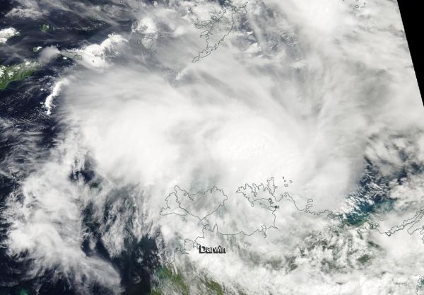
Tropical Cyclone Marcus has developed off the coast of Australia’s Northern Territory along the Cobourg Peninsula coast. NASA’s Aqua satellite provided a view of the new storm from its orbit in space.
NASA’s Aqua satellite provided a visible light image of Marcus after it developed. The Moderate Resolution Imaging Spectroradiometer, or MODIS, instrument aboard Aqua revealed that Marcus’s center of circulation just north of the Cobourg Peninsula. The image showed powerful thunderstorms circled the low-level center and extended in a band west of the center.
The Australian Bureau of Meteorology (ABM) posted a tropical cyclone warning from Goulburn Island to Wadeye, including Darwin and the Tiwi Islands. A tropical cyclone watch applies from Wadeye to Kuri Bay.
On March 16, 2018, at 11 a.m. EDT (1500 UTC), Tropical cyclone Marcus had maximum sustained winds near 46 mph (40 knots/74 kph). It was centered near 11.1 degrees south latitude and 131.9 degrees east longitude, about 102 nautical miles northeast of Darwin, Australia. Marcus was moving to the south-southwest at 7 mph (6 knots/11 kph).
Read more at NASA/Goddard Space Flight Center
Image: On March 16, 2018, at 1:20 a.m. EDT (0520 UTC) the MODIS instrument aboard NASA's Aqua satellite provided a visible light image of newly developed Tropical Storm Marcus along Australia's Cobourg Peninsula Coast, Northern Territory. (Credit: NASA MODIS Rapid Response Team)


