Operation IceBridge, NASA’s longest-running airborne mission to monitor polar ice change, concluded this year’s springtime survey of Arctic sea and land ice on May 2. The flights, which began on March 22, covered the western basin of the Arctic Ocean and Greenland’s fastest-changing glaciers.
“This campaign achieved most of our primary objectives in surveying the state of Arctic ice," said IceBridge’s acting project scientist Joe MacGregor. “We’ve now flown many of these missions ten years in a row, a period that has included continued rapid change in both Arctic glaciers and sea ice."
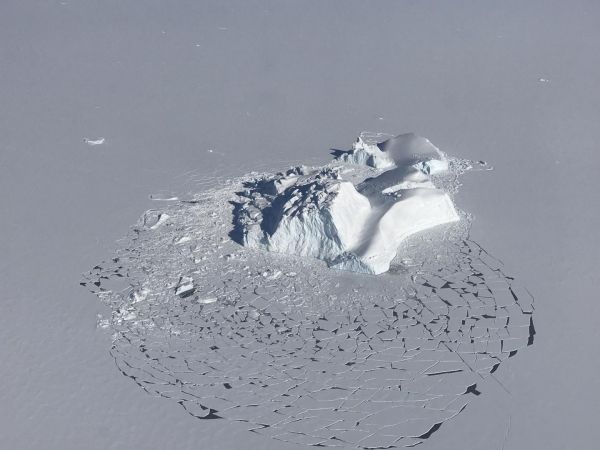
The image above was taken during a research flight carried out on April 21 near Vestfjord Glacier in Scoresby Sund, along the eastern coast of Greenland. The photo shows a large iceberg that has broken the surrounding layer of consolidated sea ice. Flat floes of sea ice with fresh snow on top, areas of open water that are beginning to refreeze and neighboring smaller icebergs are visible.
During the first weeks of the campaign, IceBridge was based in Thule Air Base, in northwest Greenland, and in Fairbanks, Alaska. From these two bases, IceBridge mapped sea ice in the Chukchi and Beaufort seas and in the central Arctic Ocean as well as the quickly evolving Petermann Glacier in northeast Greenland. On April 20, the IceBridge team relocated to Kangerlussuaq – just north of the Arctic Circle in central west Greenland – from where it launched flights to measure land ice.
Read more at NASA/Goddard Space Flight Center
Image: A large iceberg floating among sea ice floes, as seen during an operation IceBridge survey flight on Apr. 21, 2018. Credits: NASA/Linette Boisvert (Credit: NASA/Linette Boisvert)