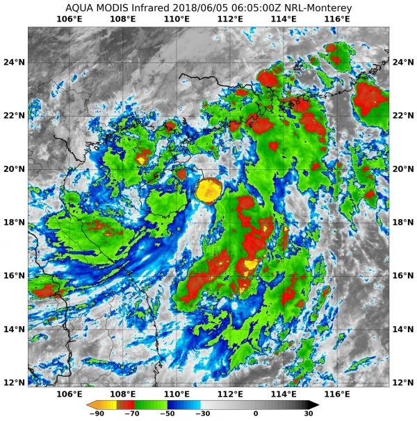
NASA obtained an infrared look at Tropical Depression 05W as it continued moving through the South China Sea. NASA's Aqua satellite found very cold cloud top temperatures and strong storms in fragmented thunderstorms mostly east of 05W's center.
NASA's Aqua satellite passed over Tropical 05W on June 5 at 2:05 a.m. EDT (0605 UTC) and analyzed the storm in infrared light to reveal cloud top temperatures. The MODIS or Moderate Resolution Imaging Spectroradiometer instrument aboard NASA's Aqua satellite revealed some cloud top temperatures in a fragmented band of thunderstorms were as cold or colder than minus 70 degrees Fahrenheit (minus 56.6 degrees Celsius). NASA research indicates very cold cloud tops with the potential to generate very heavy rainfall. The strongest storms all appeared to be over open waters in the Gulf of Tonkin and northern South China Sea.
Maximum sustained winds were near 34.5 mph (30 knots/55.5 kph) but the depression is expected to reach tropical storm strength late on June 5. 05W was centered near 19.0 degrees north latitude and 111.5 east longitude. That's approximately 269 nautical miles southwest of Hong Kong. 05W has tracked northward at 12.6 mph (11 knots/20.3 kph).
Read more at NASA / Goddard Space Flight Center
Image: NASA's Aqua satellite revealed some cloud top temperatures in fragmented thunderstorms as cold or colder than minus 70 degrees (red) Fahrenheit (minus 56.6 degrees Celsius) on Tropical Depression 05W on June 5 at 2:05 a.m. EDT (0605 UTC). CREDITS: NASA / NRL


