Surface air temperature (SAT) is a very important hydrological and climatic variable in western China. In contrast to the monsoon regions in eastern China, most regions in western China are arid, semi-arid or subject to snow cover. Thus, variations of SAT in summer in western China are key in connection with heat waves, the hydrological cycle, ecosystems and agriculture. The ability to predict SAT skillfully is an important target for science.
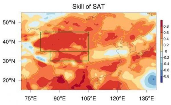
In a recent paper published in Advances in Atmospheric Sciences, a group of scientists from the Institute of Atmospheric Physics, Chinese Academy of Sciences and the UK Met Office’s Hadley Center reveal useful predictions of SAT in western China, using the GloSea5 operational forecast system from the UK Met Office. The SAT reproduced by the model shows high correlation with observations over most regions of western China, in both northwestern China and the Tibetan Plateau (see figure, below).
Read more at Institute of Atmospheric Physics, Chinese Academy of Sciences
Image: Prediction skill (temporal correlation coefficients) of summer SAT for GloSea5 hindcasts. The yellow contours represent grid-point statistical significance exceeding the 5 percent confidence level. The green boxes indicate the domains of northwestern China (35°-45°N, 80°-105°E) and the Tibetan Plateau (30°-35°N, 85°-105°E). (Credit: Chaofan Li)


