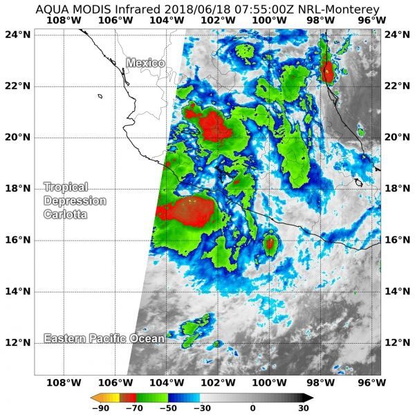
Tropical Depression Carlotta continues to hug the coast of southwestern Mexico and drop heavy rainfall. NASA's Aqua satellite provided a look at cloud top temperatures through infrared imagery to find out where the most powerful parts of Tropical Depression Carlotta were located.
NASA's Aqua satellite found very cold cloud top temperatures and strong storms in fragmented thunderstorms over mainland Mexico and the Eastern Pacific Ocean.
On June 18 at 3:55 a.m. EDT (0755 UTC) the MODIS or Moderate Resolution Imaging Spectroradiometer instrument aboard NASA's Aqua satellite revealed some cloud top temperatures in a fragmented band of thunderstorms were as cold or colder than minus 70 degrees Fahrenheit (minus 56.6 degrees Celsius).
NASA research indicates very cold cloud tops with the potential to generate very heavy rainfall. That heavy rainfall is reflected in the forecast from the National Hurricane Center who noted "Carlotta is forecast to produce 3 to 6 inches of rainfall along the Guerrero, Michoacan, and Colima coasts, with isolated higher amounts of 10 inches possible. These rains are likely to produce life-threatening flash floods and mudslides, especially in areas of higher terrain. Elsewhere across the states of Guerrero and Michoacan, rainfall amounts of 1 to 2 inches with isolated amounts of 4 inches are forecast."
Read more at National Aeronautics and Space Administration (NASA)
Image: NASA's Aqua satellite revealed some cloud top temperatures in fragmented thunderstorms as cold or colder than minus 70 degrees (red) Fahrenheit (minus 56.6 degrees Celsius) on Tropical Depression Carlotta on June 18 at 3:55 a.m. EDT (0755 UTC). CREDITS: NASA / NRL


