When NASA's Aqua satellite passed over Hurricane Fabio in the Eastern Pacific Ocean it had strengthened into a hurricane hours earlier. Infrared imagery showed that Fabio appeared more organized.
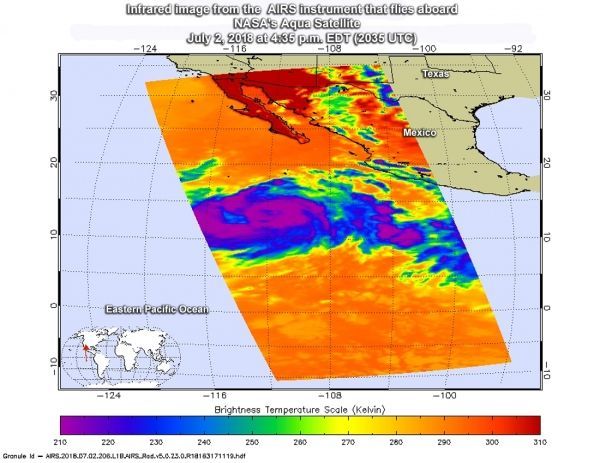
NASA's Aqua satellite passed over Hurricane Fabio on July 2 at 4:35 p.m. EDT (2035 UTC) .The Atmospheric Infrared Sounder or AIRS instrument analyzed the storm in infrared light which provides temperature information. Temperature is important when trying to understand how strong storms can be. The higher the cloud tops, the colder and the stronger they are. Cloud top temperatures were as cold as minus 63 degrees Fahrenheit (minus 53 degrees Celsius). Storms with cloud top temperatures that cold have the capability to produce heavy rainfall.
At that time, although a banding eye-like feature appeared in visible imagery, it wasn't evident in infrared data, including in the AIRS image.
The National Hurricane Center (NHC) noted on 5 a.m. EDT (0900 UTC) on July 3 "The eye has been observed intermittently on conventional imagery during the past few hours, and the convection surrounding the eye has not changed much."
Read more at NASA / Goddard Space Flight Center
Image: NASA's Aqua satellite passed over Hurricane Fabio on July 2 at 4:35 p.m. EDT (2035 UTC) and saw coldest cloud top temperatures (purple) around the center of circulation and in thick feeder bands wrapping into storm's center. CREDITS: NASA JPL / Heidar Thrastarson