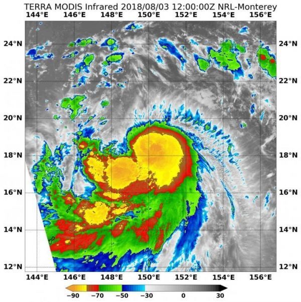
An infrared look by NASA's Terra satellite found powerful storms in the center of Tropical Storm Shanshan, the newest tropical storm in the Northwestern Pacific Ocean. Shanshan has triggered warnings in the Marianas Islands.
Tropical Depression 17W formed in the Northwestern Pacific Ocean near the Commonwealth of the Northern Marianas Islands. On Aug. 3 it strengthened into a tropical storm and was renamed Tropical Storm Shanshan.
Today, Aug. 3 EDT, the National Weather Service (NWS) in Tiyan, Guam stated that a Tropical Storm Warning remains in effect for Agrihan, Pagan and Alamagan in the Northern Commonwealth of the Northern Mariana Islands. At 8:00 a.m. EDT (1200 UTC) the Moderate Resolution Imaging Spectroradiometer or MODIS instrument aboard NASA's Terra satellite analyzed Tropical Storm Shanshan s cloud top temperatures in infrared light. MODIS found cloud top temperatures of strongest thunderstorms were as cold as or colder than minus 80 degrees Fahrenheit (minus 62.2 Celsius) around the center. Cloud top temperatures that cold indicate strong storms that have the capability to create heavy rain.
Read more at NASA/Goddard Space Flight Center
Image: On Aug. 3 at 8:00 a.m. EDT (1200 UTC) NASA's Terra satellite found coldest temperatures of strongest thunderstorms (yellow) in Tropical Storm Shanshan were as cold as or colder than minus 80 degrees Fahrenheit (minus 62.2 Celsius). (Credit: NRL/NASA)


