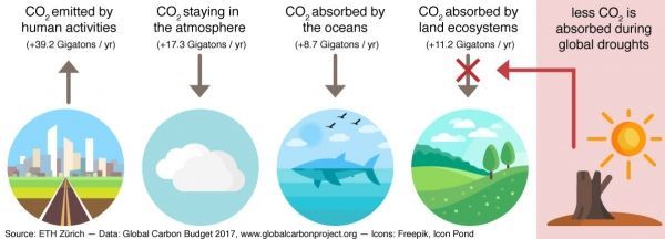
Land ecosystems absorb on average 30% of anthropogenic CO2 emissions, thereby tempering the increase of CO2 concentration in the atmosphere. But plants need water to grow. When a drought occurs, and soils dry out, plants reduce photosynthesis and breathe less in order to save water and preserve their tissues. As a consequence, they are no longer able to capture carbon dioxide from the surrounding air and more CO2 remains in the air. While this effect can be easily observed in the lab, measuring its impact on the whole planet has proved quite difficult. One of the greatest challenges has been to measure where and how often droughts occur globally. In a new study, Vincent Humphrey, climate researcher in the lab of Sonia Seneviratne, Professor for Land-Climate Dynamics at ETH Zurich, used innovative satellite technology to measure the global sensitivity of ecosystems to water stress. The study was carried out in collaboration with the Laboratoire des Sciences du Climat et de l'Environnement (France) and the University of Exeter (United Kingdom).
Using satellites to measure droughts
Plants are usually able to access water deep in the soil through their roots. However, conventional satellites only see what happens at the surface and cannot measure how much water is available underground. In the last few years, a new type of satellite mission has been used to measure extremely small changes in the Earth’s gravity field. It was found that some small perturbations of the gravity field are caused by changes in water storage. When there is a major drought in a given region, there is less water mass and gravity is consequently slightly weaker over that region. Such variations are so small that they are imperceptible to humans. But by measuring them with satellites, scientists are able to estimate large-scale changes in water storage to an accuracy of about four centimetres everywhere on the planet.
Read more at ETH Zurich
Image Credit: ETH Zurich