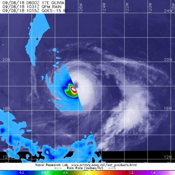
The Global Precipitation Measurement mission or GPM satellite passed over Hurricane Olivia and found heaviest rain in a tight ring around the eye.
On Sept. 6 at 6:31 a.m. EDT (1031 UTC) the GPM core satellite provided an analysis of rainfall rates occurring in Hurricane Olivia. GPM found that heaviest rainfall rates were occurring around the eye at a rate of 1.5 inches (38 mm) per hour. Because the storm is compact, that area of heavy rainfall was also compact. Hurricane-force winds extend outward up to 25 miles (35 km) from the center and tropical-storm-force winds extend outward up to 115 miles (185 km).
At 5 a.m. EDT (0900 UTC) on Sept. 6, the National Hurricane Center or NHC noted the center of Hurricane Olivia was located near latitude 18.2 degrees north and longitude 126.5 degrees west. That’s about 1,125 miles (1,805 km) west-southwest of the southern tip of Baja California, Mexico.
Read more at NASA/Goddard Space Flight Center
Image: On Sept. 6, 2018 at 6:31 a.m. EDT (1031 UTC) the GPM core satellite provided an analysis of rainfall rates occurring in Hurricane Olivia. Strongest rainfall was occurring around the eye at a rate of 1.5 inches (38 mm) per hour (pink). The GPM data was overlaid on infrared cloud imagery from NOAA's GOES-West satellite. (Credit: NASA/JAXA/NRL/NOAA)


