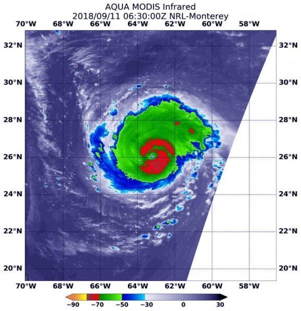
NASA’s Aqua satellite provided an infrared look at powerful Hurricane Florence early on Sept. 11 that indicated it was likely undergoing eyewall replacement.
Intense hurricanes can and often undergo an eyewall replacement cycle. That happens when a new eyewall or ring of thunderstorms within the outer rain bands forms further out from the storm’s center, outside of the original eye wall. That ring of thunderstorms then begins to choke off the original eye wall, starving it of moisture and momentum. Eventually, if the cycle is completed, the original eye wall of thunderstorms dissipates and the new outer eye wall of thunderstorms contracts and replace the old eye wall. The storm’s intensity can fluctuate over this period, initially weakening as the inner eye wall dies before again strengthening as the outer eye wall contracts.
Infrared and Microwave Satellite Images Reveal
NOAA’s National Hurricane Center (NHC) said that recent satellite imagery shows that the eye of Florence has become cloud filled. A microwave image of the storm at 12:41 a.m. EDT (0441 UTC) showed a double eyewall structure. These observations suggest that an eyewall replacement cycle is likely underway.
At 2:30 a.m. EDT (0630 UTC) on Sept. 11, Moderate Resolution Imaging Spectroradiometer or MODIS instrument aboard NASA’s Aqua satellite analyzed Hurricane Florence in infrared light. MODIS found coldest cloud top temperatures around the eye, as cold as or colder than minus 80 degrees Fahrenheit (F)/minus 112 degrees Celsius (C). Surrounding the eye were thick rings of powerful storms with cloud tops as cold as or colder than minus 70F (minus 56.6C).
Read more at NASA/Goddard Space Flight Center
Image: At 2:30 a.m. EDT (0630 UTC) on Sept. 11, 2018 the MODIS instrument aboard NASA's Aqua satellite looked at Hurricane Florence in infrared light. MODIS found coldest cloud top temperatures around the eye, as cold as or colder than minus 80 degrees (yellow) Fahrenheit (minus 112 degrees Celsius). Surrounding the eye were thick rings of powerful storms with cloud tops as cold as or colder than minus 70 degrees (red) Fahrenheit (minus 56.6 degrees Celsius). (Credit: NASA/NRL)


