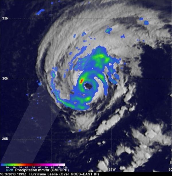
When Tropical Storm Leslie strengthened into a hurricane, the Global Precipitation Measurement mission or GPM core satellite passed overhead and analyzed the rates in which rain was falling throughout the stronger storm.
Although Leslie is in the Central Atlantic Ocean, it’s strong enough to generate dangerous ocean swells that will continue to affect portions of the southeastern coast of the United States, Bermuda, and the Bahamas during the next few days. Swells are expected to increase near the coasts of New England and Atlantic Canada by the end of the week.
The GPM core observatory satellite passed above Hurricane Leslie on Oct. 3, 2018 at 7:33 a.m. EDT (1133 UTC). GPM is a joint mission between NASA and the Japan Aerospace Exploration Agency or JAXA.
At the time GPM passed overhead, Leslie had just been upgraded to a hurricane by the National Hurricane Center (NHC). GPM’s Microwave Imager (GMI) instruments collected data that revealed light to moderate convective rainfall in Leslie’s clearly evident eye wall. Very little precipitation was shown by GPM in the center of the hurricane’s nearly circular eye. Algorithms developed by NASA’s Precipitation Measurement Missions (PMM) science team indicated that rain was falling at over 1.8 inches (45.7 mm) per hour within storms located in the northwestern side of the Leslie’s eye wall.
Read more at NASA/Goddard Space Flight Center
Image: The GPM or Global Precipitation Measurement mission core observatory satellite passed above Hurricane Leslie on Oct. 3, 2018 at 7:33 a.m. EDT (1133 UTC) and found rain was falling at over 1.8 inches (45.7 mm) per hour within storms located in the northwestern side of the Leslie's eye wall. (Credit: NASA/JAXA, Hal Pierce)


