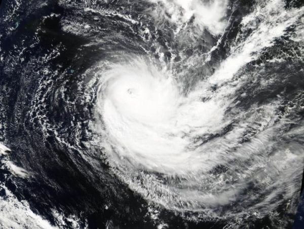
Tropical Cyclone Joaninha is not yet ready to close its eye and weaken. Visible imagery from NASA’s Terra satellite showed Tropical Cyclone Joaninha maintaining an eye thanks to low wind shear and warm sea surface temperatures.
On March 28 the Moderate Resolution Imaging Spectroradiometer or MODIS instrument aboard NASA’s Terra satellite provided a visible image of Joaninha. Joaninha had maintained its eye, although appearing more ragged looking than in satellite imagery the previous day. The ragged eye was surrounded by powerful thunderstorms in a thick eyewall.
Moving Through Warm Sea Surface Temperatures
The sea surface temperatures in the area of the tropical cyclone were still warm enough to support and maintain the tropical cyclone. Infrared satellite imagery provides sea surface temperature data. Tropical cyclones need sea surface temperatures of at least 26.6 degrees Celsius (80 degrees Fahrenheit) and Joaninha is moving through an area where the sea surface temperatures range between 26 and 28 degrees Celsius (78.8 and 82.4 degrees Fahrenheit).
Read more at NASA/Goddard Space Flight Center
Image: On March 28, 2019, the MODIS instrument aboard NASA's Terra satellite provided a visible image of Tropical Cyclone Joaninha in the Southern Indian Ocean. (Credit: NASA Worldview, Earth Observing System Data and Information System (EOSDIS))


