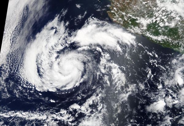
Visible imagery from NASA’s Terra satellite showed Tropical Storm Alvin had organized and strengthened into a strong tropical storm, just over 500 miles from Mexico’s Baja California peninsula.
On June 27, the Moderate Resolution Imaging Spectroradiometer or MODIS instrument aboard NASA’s Terra satellite provided a visible image of Alvin. Satellite imagery revealed that Alvin’s clouds appeared more organized than they did the previous day.
Recent microwave imagery also showed that Alvin’s “convective structure,” or the development and organization of thunderstorms around the low-level center) has improved during the morning of June 27. AT 6:57 a.m. EDT (1057 UTC). The Special Sensor Microwave/Imager (SSM/I) instrument aboard Defense Meteorological Satellite Program satellite showed a closed ring of convection (clouds and storms) around the mid-level center of the small tropical storm. Infrared satellite imagery revealed that Alvin has not changed significantly.
Read more at NASA / Goddard Space Flight Center
Image: On June 27, 2019, the MODIS instrument aboard NASA’s Terra satellite provided a visible image of Tropical Cyclone Alvin, located over 500 miles west of Baja California, Mexico. Credit: NASA Worldview, Earth Observing System Data and Information System (EOSDIS)


