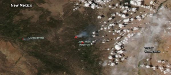
The U.S. Forest Service’s Gila National Forest reported four naturally caused fires on July 4, 2019, and three of them generated enough smoke to be seen from space by satellite.
On July 4, Inciweb, an interagency all-risk incident information management reported the four fires burning in the Gila National Forest were all sparked by lightning. They include the Black Fire, Little Fire, South Fire and Woodrow Fire.
On July 4, the Visible Infrared Imaging Radiometer Suite (VIIRS) instrument aboard Suomi NPP provided a visible image of the Gila National Forest. The VIIRS image showed three of the fires were generating smoke plumes that could be seen from space as Suomi NPP passed overhead. Two of the plumes were in the Aldo Leopold Wilderness part of the Gila National Forest. The third plume was located west of the Aldo Leopold Wilderness area. The smoke from all fires appeared light brown. VIIRS also detected heat signatures of the fires, and those appear in a red color.
Inciweb reported that the Black Fire is approximately 530 acres, burning on National Forest System lands in the Aldo Leopold Wilderness. The lightning-caused South Fire is approximately 780 acres is also in the Aldo Leopold Wilderness, Gila National Forest. Both of these fires generated enough smoke to be seen by NASA-NOAA’s Suomi NPP satellite.
Read more at: NASA/GODDARD SPACE FLIGHT CENTER
On July 4, the Visible Infrared Imaging Radiometer Suite (VIIRS) instrument aboard Suomi NPP provided a visible image of the Gila National Forest. The VIIRS image showed three of the fires were generating smoke plumes that could be seen from space as Suomi NPP passed overhead. Two of the plumes were in the Aldo Leopold Wilderness part of the Gila National Forest. The third plume was located west of the Aldo Leopold Wilderness area. The smoke from all fires appeared light brown. VIIRS also detected heat signatures of the fires, and those appear in a red color. (Photo Credit: NASA Worldview, Earth Observing System Data and Information System (EOSDIS)/NOAA)


