Canada has been battling a very active and destructive fire season on multiple fronts this year. A warming climate, very dry environment, and more extreme weather including severe thunderstorms has led to massive wildfires throughout the country.
Two of the provinces hardest hit by these fires are Ontario and Manitoba. On July 7, 2019, the Suomi NPP satellite using its VIIRS (Visible Infrared Imaging Radiometer Suite) instrument captured this image of the fires ongoing in the region. Also visible in this image is the massive amount of smoke pouring off these fires and moving southeast into other parts of Ontario, over the Great Lakes, and into Michigan. Small amounts are also seen drifting into Minnesota.
The smoke will continue to drift southward as it's carried on the jet stream. Actively burning areas, detected by VIIRS’s thermal bands, are outlined in red. Suomi NPP is managed by NASA and NOAA.
Read more at NASA / Goddard Space Flight Center
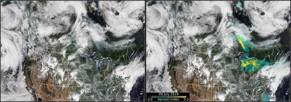
Image: Smoke from the Ontario fires continues to affect the Great Lakes region. The image on the left is from the VIIRS instrument aboard that NOAA-20 satellite, and the image on the right is from the OMPS aerosol index overlaid on the VIIRS image. The advanced Ozone Mapping and Profiler Suite (OMPS) tracks the health of the ozone layer and measures the concentration of ozone in the Earth's atmosphere and the yellow areas over the great lakes are aerosols from the wildfire smoke. Credits: NASA/NOAA/Colin Seftor