During Dive 14 of the Windows to the Deep 2019 expedition, NOAA’s remotely operated vehicle (ROV) Deep Discoverer, also known as D2, explored cold seeps arrayed along a ridge located about 62 kilometers (39 miles) offshore Bodie Island, North Carolina. These methane seeps had never before been visited by autonomous, remotely operated, or human-occupied vehicles, and scientists were excited to watch as D2 made new discoveries during its progress up the ridge.
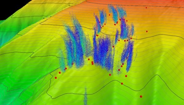
Like the hundreds of other methane seeps identified on the U.S. Atlantic margin since 2012, the Bodie Island seep field was first discovered based on the analysis of water column acoustic images that revealed gas bubbles rising in plumes above the site. Researchers from Mississippi State University used NOAA Ship Okeanos Explorer multibeam sonar data collected in 2012 and 2014 to map a line of methane plumes emanating from near the spine of a ridge, at roughly 415-360 meters (1,362-1,181 feet) water depth. In 2017, the U.S. Geological Survey (USGS) mapped some of the same plumes and located a few more in the larger seep field using an EK80 fisheries sonar and a different multibeam system. Although the Bodie Island seep field plumes had been mapped several times over the past few years, it was not until the Okeanos Explorer collected new water column data in the days before the Windows to the Deep 2019 dive that researchers were reassured that the seeps were still active.
Continue reading at NOAA.
Image via NOAA.