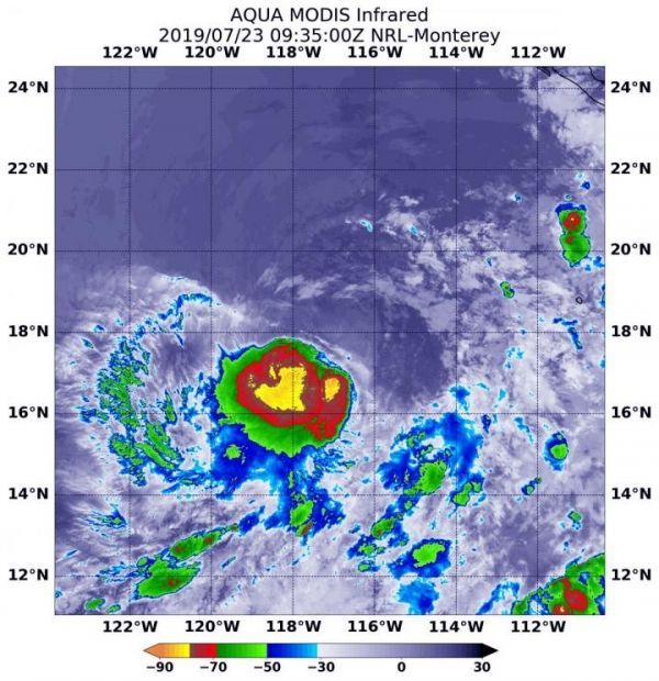
NASA’s Aqua satellite used infrared light to analyze the strength of storms circled the center of circulation, a change from 24 hours before when wind shear pushed them away from the center. Now, the storm appears much more circular.
Infrared data provides temperature information, and the strongest thunderstorms that reach high into the atmosphere have the coldest cloud top temperatures.
On July 23 at 5:35 a.m. EDT (0935 UTC), the Moderate Imaging Spectroradiometer or MODIS instrument that flies aboard NASA’s Aqua satellite gathered infrared data on the strengthened Tropical Storm Dalila. Strongest thunderstorms had cloud top temperatures as cold as minus 80 degrees Fahrenheit (minus 62.2 Celsius). Cloud top temperatures that cold indicate strong storms with the potential to generate heavy rainfall.
At 5 a.m. EDT (0900 UTC) on July 23, the National Hurricane Center (NHC) the center of newly formed Tropical Storm Dalila was located near latitude 18.0 degrees north and longitude 117.3 degrees west. That is about 585 miles (945) km) southwest of the southern tip of Baja California, Mexico. There are no coastal watches or warnings in effect.
Read more at: NASA/Goddard Space Flight Center
On July 23 at 5:35 a.m. EDT (0935 UTC), the MODIS instrument that flies aboard NASA's Aqua satellite showed strongest storms (yellow) in Tropical Storm Dalila had cloud top temperatures as cold as minus 80 degrees Fahrenheit (minus 62.2 Celsius). (Photo Credit: NASA/NRL)


