Erick developed as Tropical Depression Six-E on Saturday, July 27, 2019. It formed about 1,215 miles (1,955 km) southwest of the southern tip of Baja California. Mexico. At 5:15 p.m. EDT that day, it strengthened into a tropical storm and was re-named Erick.
NASA’s Aqua satellite used infrared light to analyze the strength of storms and found the bulk of them in the southern quadrant. Infrared data provides temperature information, and the strongest thunderstorms that reach high into the atmosphere have the coldest cloud top temperatures.
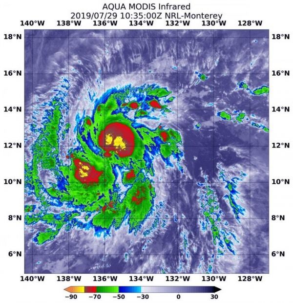
On July 29 at 6:35 a.m. EDT (1035 UTC),the Moderate Imaging Spectroradiometer or MODIS instrument that flies aboard NASA’s Aqua satellite gathered infrared data on Tropical Storm Erick were around the center and in a band of thunderstorms southwest of the center where cloud top temperatures were as cold as minus 70 degrees Fahrenheit (minus 56.6 Celsius).
Cloud top temperatures that cold indicate strong storms with the potential to generate heavy rainfall. Those strongest storms were south and southeast of the center of the elongated circulation. Recent microwave data reveal the development of an eye.
Read more at: NASA/Goddard Space Flight Center
On July 29, 2019 at 6:35 a.m. EDT (1035 UTC) the MODIS instrument that flies aboard NASA's Aqua satellite showed strongest storms in Tropical Storm Erick were around the center and in a band of thunderstorms southwest of the center where cloud top temperatures were as cold as minus 70 degrees Fahrenheit (minus 56.6 Celsius). (Photo Credit: NASA/NRL)


