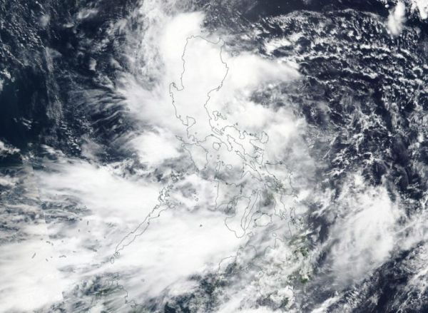
Tropical Depression 13W, now named Podul, was crossing the Philippines from east to west as NASA-NOAA’s Suomi NPP satellite provided a visible image of the storm.
Podul’s trek across the country triggered many Philippines warnings on August 27, 2019. Tropical cyclone wind signal #2 is in effect over the following Luzon provinces: Isabela, Aurora, Quirino, Nueva Vizcaya, Ifugao, Mountain Province, Ifugao, Benguet, Ilocos Sur, La Union and Pangasinan. Tropical cyclone wind signal #1 is in effect over the following Luzon provinces: Cagayan, Apayao, Abra, Kalinga, Ilocos Norte, Nueva Ecija, Tarlac, Zambales, Bataan, Pampanga, Bulacan, Metro Manila, Rizal, northern portion of Quezon including Polillo Island and Alabat Island, Cavite, Laguna, Camarines Norte, northeastern portion of Camarines Sur and Catanduanes.
The Visible Infrared Imaging Radiometer Suite (VIIRS) instrument aboard Suomi NPP provided a visible image of the storm on August 27, 2019. The VIIRS image showed the storm blanketed the country from north to south. The bulk of the clouds were located over the northern and central Philippines.
Read more at NASA / Goddard Space Flight Center
Image: On August 27, 2019, NASA-NOAA’s Suomi NPP satellite passed over the South China Sea and captured a visible image of Tropical Storm Podul. Credit: NASA Worldview, Earth Observing System Data and Information System (EOSDIS).


