NASA’s Aqua satellite provided forecasters at the National Hurricane Center with infrared data and cloud top temperature information on Hurricane Kiko. Wind shear was affecting the storm and had closed the eye.
On Monday, September 16, 2019, microwave data and satellite imagery continue to indicate that the core of Kiko is being disrupted. Wind shear from the northeast is preventing Kiko from having a closed eyewall circulation. That means that the storm is subject to outside winds and can weaken.
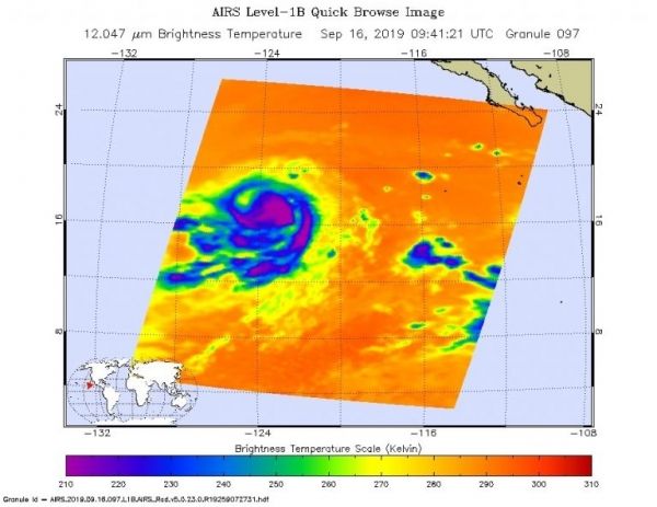
NASA researches tropical cyclones. One of the ways NASA does that is with infrared data that provides temperature information. Cloud top temperatures provide information to forecasters about where the strongest storms are located within a tropical cyclone. Tropical cyclones do not always have uniform strength, and some sides have stronger sides than others. The stronger the storms, the higher they extend into the troposphere, and they have the colder cloud temperatures.
Read more at NASA / Goddard Space Flight Center
Image: On Sept. 16 at 5:41 a.m. EDT (0941 UTC) the AIRS instrument aboard NASA’s Aqua satellite analyzed cloud top temperatures of Hurricane Kiko in infrared light. AIRS found coldest cloud top temperatures (purple) of strongest thunderstorms were as cold as or colder than minus 63 degrees Fahrenheit (minus 53 degrees Celsius) around the center and in a large bands east and west of center. Credit: NASA JPL/Heidar Thrastarson