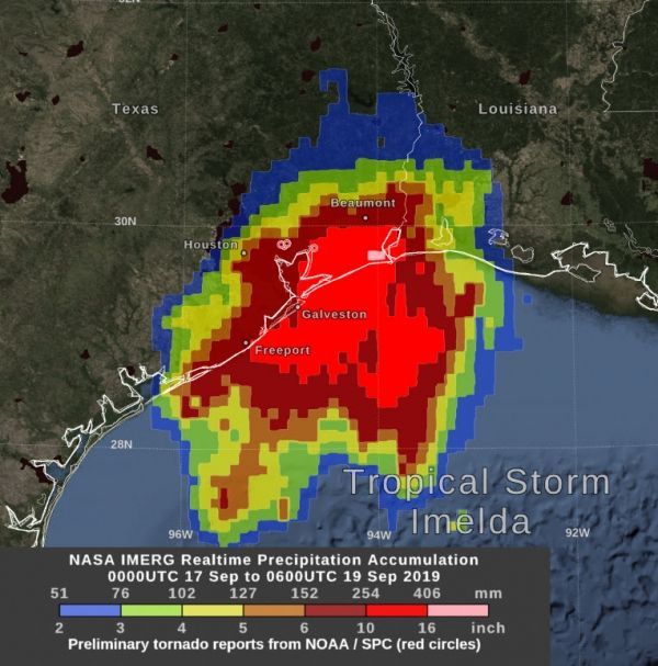
Northeastern Texas has borne the brunt of Tropical Depression Imelda’s heavy rainfall and NASA estimated that rainfall with an algorithm that incorporates data from satellites and observations.
By Thursday morning, September 19, Tropical Storm Imelda had dropped over 10 inches of rain over a large area between Houston and Beaumont, Texas. At NASA’s Goddard Space Flight Center in Greenbelt, Maryland, a graphic was produced that shows precipitation that fell starting on Tuesday, September 17, the day that Imelda formed as a tropical depression in the Gulf of Mexico, intensified into a tropical storm, and made landfall in Texas, all within a few hours.
The near-realtime rain estimate comes from the NASA’s Integrated Multi-satellitE Retrievals for GPM (IMERG) algorithm, which combines observations from a fleet of satellites, in near-realtime, to provide near-global estimates of precipitation every 30 minutes. This satellite-based rain estimate is somewhat coarse in resolution and can miss short-lived, intense storm-cells, but the IMERG algorithm often does captures the large-scale features of storms wherever they form in the world. While the United States is fortunate to have a network of ground radars that can provide higher-resolution precipitation estimates, in other parts of the world, notably over most of the world’s oceans, the IMERG rain estimate is an important reference point.
Read more at NASA / Goddard Space Flight Center
Image: NASA’s IMERG estimated that by Thursday morning, September 19, Tropical Storm Imelda had dropped over 10 inches of rain (red) over a large area between Houston and Beaumont, Texas. There were several preliminary reports of tornadoes (small red circles) on Wednesday evening, September 18. Credit: NASA Goddard/Owen Kelley


