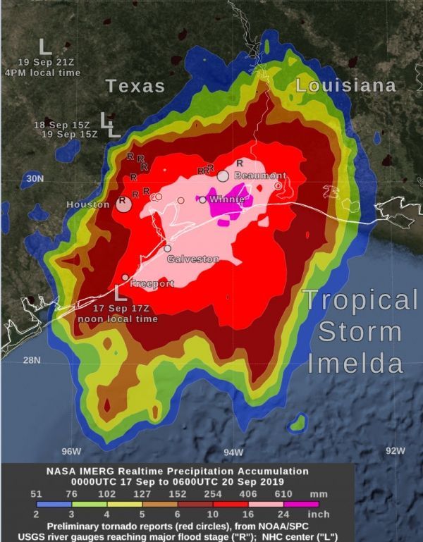
NASA estimated extreme rainfall over eastern Texas from the remnants of Tropical Depression Imelda, using an algorithm that incorporates data from satellites and observations.
By Friday morning, September 20, the rainfall from the remnants of Tropical Storm Imelda had increased to over 24 inches in some areas near the Gulf of Mexico coast, between Beaumont and Houston, Texas. This rainfall was in excess of what had been forecasted a few days earlier and was due to Imelda’s forward motion ceasing for approximately 24 hours between Wednesday, Aug. 18 and Thursday afternoon, Aug. 19.
NASA’s Integrated Multi-satellitE Retrievals for GPM or IMERG algorithm estimated that by Friday morning, September 20, Tropical Storm Imelda had dropped over 24 inches of rain between Beaumont and Houston, Texas. Estimates of between 16 and 24 inches have fallen between Freeport and Beaumont, and 6 inches and more over a large area between southwestern Louisiana and Palacios, Texas. An image showing these rainfall totals was created at NASA’s Goddard Space Flight Center in Greenbelt, Md.
Read more at NASA / Goddard Space Flight Center
Image: NASA’s IMERG estimated that by Friday morning, September 20, Tropical Storm Imelda had dropped over 24 inches of rain (dark pink) between Beaumont and Houston, Texas. Estimates of between 16 and 24 inches have fallen (light pink) between Freeport and Beaumont, and 6 inches and more (red) over a large area between southwestern Louisiana and Palacios, Texas. Large “L” symbols show Imelda’s location estimated by the National Hurricane Center. An “R” symbol on the image indicates a place where the rainfall from the remnant of Imelda caused a U.S. Geological Survey river gauge to swell to “major flood” stage. Red circles on this image indicate the location of these tornado reports, as provided by NOAA’s Storm Prediction Center. Credit: NASA Goddard


