NASA’s Suomi NPP satellite passed over North Atlantic Ocean on Oct. 14 and provided forecasters with an infrared view of Tropical Storm Melissa that revealed wind shear was tearing the storm apart as it was becoming extra-tropical.
NASA’s Suomi NPP satellite used infrared light to analyze the strength of storms in Tropical Storm Melissa. Infrared data provides temperature information and the strongest thunderstorms that reach high into the atmosphere have the coldest cloud top temperatures.
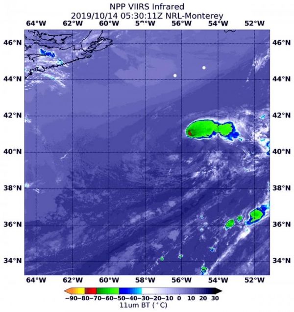
Melissa became an extra-tropical cyclone on Monday, Oct. 14. The only thunderstorms and precipitation associated with the circulation were displaced up to 100 miles east of the center in this infrared image from NASA-NOAA’s Suomi NPP satellite on Oct. 14, 2019 at 1:30 a.m. EDT (0530 UTC). That area had cloud top temperatures as cold as or colder than minus 70 degrees Fahrenheit (minus 56.6 Celsius). Cloud top temperatures that cold indicate strong storms with the potential to generate heavy rainfall and that area was being pushed northeast by southwesterly wind shear. In general, wind shear is a measure of how the speed and direction of winds change with altitude. Tropical cyclones are like rotating cylinders of winds. Each level needs to be stacked on top each other vertically in order for the storm to maintain strength or intensify. Wind shear occurs when winds at different levels of the atmosphere push against the rotating cylinder of winds, weakening the rotation by pushing it apart at different levels.
Read more at NASA/Goddard Space Flight Center
Image: On Oct. 14, 2019 at 1:30 a.m. EDT (0530 UTC), the MODIS instrument that flies aboard NASA-NOAA's Suomi satellite revealed that Melissa was being adversely affected by wind shear that was pushing all storms northeast of the center. In that area, cloud top temperatures were as cold as minus 70 degrees Fahrenheit (minus 56.6 Celsius). (Credit: NASA/NRL)