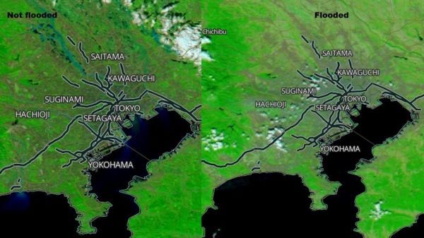
Typhoon Hagibis made landfall in Japan over the weekend of October 12 and 13, bringing damaging winds, rough surf and flooding rains. NASA’s Aqua satellite provided a visible image of the flooding caused by the torrential rainfall.
Hagibis made landfall just before 6 a.m. EDT (7 p.m. local time, Japan) on Oct. 12, on the Izu Peninsula, located southwest of Tokyo.
On Oct. 12 at 5 p.m. EDT (2100 UTC), the Joint Typhoon Warning Center issued their final bulletin on Tropical Cyclone Hagibis. The storm has moved off Japan and re-emerged in the Northwestern Pacific Ocean where it is becoming extra-tropical. On Oct. 12 at 5 p.m. EDT, Hagibis was located near 28.6 north latitude and 141.9 east longitude, about 113 nautical miles south-southeast of Misawa, Japan. Hagibis was speeding to the northeast at 36 knots (41 mph/67 kph) and had maximum sustained winds 65 knots (75 mph/120 kph), still at hurricane-strength.
Continue reading at NASA Goddard Space Flight Center
Image via NASA Worldview