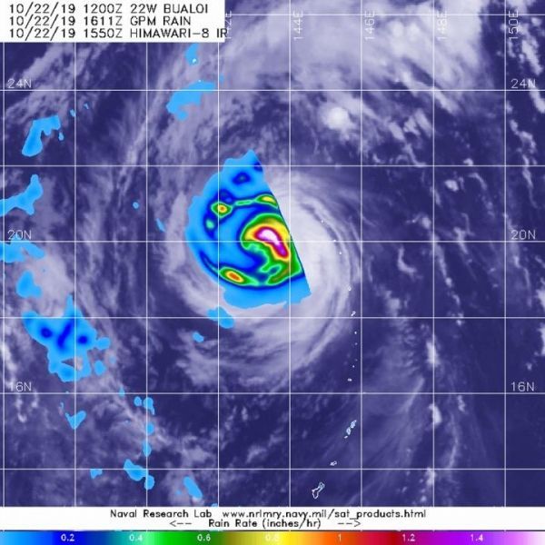
Typhoon Bualoi continues to move through the Northwestern Pacific Ocean and the Global Precipitation Measurement mission or GPM core satellite measured rainfall rates throughout the storm.
The GPM’s core satellite passed over Typhoon Bualoi on Oct. 22 at 12:11 p.m. EDT (1611 UTC). GPM found the heaviest rain around the eye, falling at a rate of over 50 mm (about 2 inches) per hour. Forecasters at NOAA’s National Hurricane Center or NHC incorporate the rainfall data into their forecasts.
At 5 a.m. EDT (7 p.m. ChST/0900 UTC) the center of Typhoon Bualoi was located near latitude 23.5 degrees north and longitude 142.0 degrees east. The National Weather Service in Tiyan, Guam noted that it is about 405 miles northwest of Agrihan. Bualoi is now moving north-northwest at 13 mph and will continue a gradual turn to the north tonight and then toward the north-northeast through Thursday night. Maximum sustained winds have decreased to 115 mph and Bualoi is expected to continue this weakening trend the next several days. Bualoi is expected to gradually increase in forward speed as it heads farther into the north Pacific east of Japan.
Read more at: NASA/Goddard Space Flight Center
The GPM core satellite passed over strengthening Typhoon Bualoi in the Northwestern Pacific Ocean on Oct. 22 at 12:11 p.m. EDT (1611 UTC) and found the heaviest rainfall (white/pink) falling at a rate of over 50 mm (about 2 inches) per hour. (Photo Credit: NASA/JAXA/NRL)


