Matmo strengthened from a tropical storm to a storm with hurricane-force in the overnight hours of Nov. 7 into Nov. 8. NASA-NOAA’s Suomi NPP satellite passed over the Bay of Bengal, Northern Indian Ocean and found Matmo appeared more organized. Warnings are in effect in northeastern India and Bangladesh as Matmo approaches.
Visible imagery from the Visible Infrared Imaging Radiometer Suite (VIIRS) instrument aboard NASA-NOAA’s Suomi NPP satellite on Nov. 8 showed Matmo appeared more circular indicating it may have intensified. The imagery also showed a large band on thunderstorms extending north from the center of circulation and over northeastern India and Bangladesh.
The satellite imagery showing better organization complemented the increase in Matmo’s maximum sustained winds. Sustained winds on Nov. 7 were near 55 knots (63 mph/102 kph). On Nov. 8 at 10 a.m. EST (1500 UTC), Matmo’s maximum sustained winds had increased to near 85 knots (98 mph/157 kph). Matmo was located near latitude 19.1 degrees north and longitude 88.1 degrees east, about 235 nautical miles south of Kolkata, India. Matmo is moving to the north.
Read more at NASA/Goddard Space Flight Center
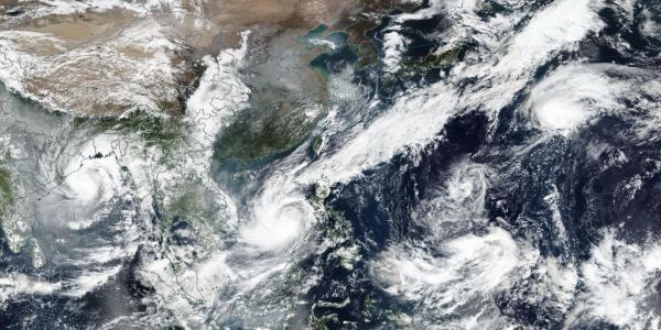
Image: NASA-NOAA's Suomi NPP satellite provided a panoramic image of 3 tropical cyclones in the northern hemisphere. Cyclone Matmo (left) in the Bay of Bengal, Northern Indian Ocean, Typhoon Nakri (center) in the South China Sea, and Tropical Storm Halong (right) in the Northwestern Pacific Ocean. (Credit: NASA Worldview, Earth Observing System Data and Information System (EOSDIS))