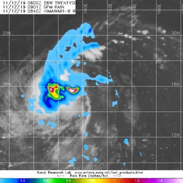
The Global Precipitation Measurement mission or GPM core satellite provided a look at the rainfall occurring within the newly developed Tropical Storm Fengshen.
Tropical Depression 26W formed in the Northwestern Pacific Ocean on Nov. 11 and strengthened into a tropical storm. Once it strengthened it was renamed Fengshen.
GPM passed over Fengshen on Nov. 12 at 3:40 a.m. EDT (0840 UTC) and found heavy rainfall in several areas exceeding 1.6 inches (40 mm) per hour around a consolidating low-level center.
At 10 a.m. EDT (1500 UTC) on Nov. 12 (1 a.m. CHST, Nov. 13) the National Weather Service in Tiyan, Guam said the center of Tropical Storm Fengshen was located near latitude 16.3 degrees north and longitude 158.6 degrees east. Fengshen is moving west-northwest at 16 mph and is expected to maintain this general course and speed through Thursday, then turn slightly to the northwest on Friday the 15th where it is forecast to pass just north of Agrihan. Maximum sustained winds have increased to 40 mph and Fengshen is forecast to gradually intensify through Friday. Tropical storm force winds extend outward from the center up to 15 miles.
Read more at NASA / Goddard Space Flight Center
Image: GPM passed over Tropical Storm Fengshen on Nov. 12 at 3:40 a.m. EDT (0840 UTC) and found heavy rainfall in several areas exceeding 1.6 inches (40 mm) per hour. Credit: NASA/NRL


