Tropical Storm Sebastian continued to move in a northeasterly direction through the North Atlantic Ocean as NASA’s Aqua satellite passed overhead. Infrared imagery from an instrument aboard Aqua revealed very high, powerful storms with very cold cloud top temperatures in the southwestern quadrant of the storm. It also revealed that the storm was being sheared apart by outside winds.
ITropical cyclones are made of up hundreds of thunderstorms and infrared data can show where the strongest storms are located. They can do that because infrared data provides temperature information, and the strongest thunderstorms that reach highest into the atmosphere have the coldest cloud top temperatures.
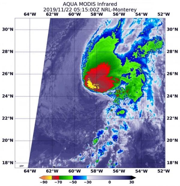
On Nov. 22 at 1:15 a.m. EST (0515 UTC), the Moderate Resolution Imaging Spectroradiometer or MODIS instrument that flies aboard NASA’s Aqua satellite used infrared light to analyze the strength of storms within the tropical cyclone. MODIS found those strongest storms only in the southwestern side of the storm where cloud top temperatures were as cold as or colder than minus 80 degrees Fahrenheit (minus 62.2 Celsius). NASA research has found that cloud top temperatures that cold indicate strong storms with the potential to generate heavy rainfall.
Read more at: NASA/Goddard Space Flight Center
On Nov. 22, 2019 at 1:15 a.m. EST (0515 UTC) the MODIS instrument that flies aboard NASA's Aqua satellite showed on area in Sebastien's southwestern corner where cloud top temperatures were as cold as or colder than (in yellow) minus 80 degrees Fahrenheit (minus 62.2 Celsius). (Photo Credit: NASA/NRL)