As plants grow, they remove carbon dioxide from the atmosphere and store it as biomass. This is then released back to the atmosphere through processes such as deforestation, disturbance or wildfires. Assessing these dynamic changes is key to understanding the cycling of carbon and also for informing global climate models that help predict future change.
Tracking biomass change is also becoming increasingly important as decision-makers work towards the Global Stocktake – an aspect of the global Paris climate deal -- that will periodically check international progress towards meeting emissions reduction commitments to limit global warming.
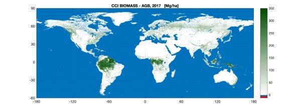
The new map uses optical, lidar and radar data acquired in 2017 and 2018 from multiple Earth observation satellites, and is the first to integrate multiple acquisitions from the Copernicus Sentinel-1 mission and Japan’s ALOS mission.
Continue reading at European Space Agency
Image via European Space Agency