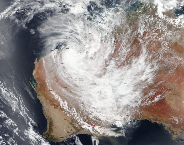
Tropical cyclone Blake made landfall in the Kimberley coast of Western Australia and NASA-NOAA’s Suomi NPP satellite provided an image that showed its center inland with the storm extending to the southern part of the state where fires raged.
On January 8, 2020, the Visible Infrared Imaging Radiometer Suite (VIIRS) instrument aboard Suomi NPP provided a visible image of Blake that showed its center was just inland from the Kimberley coast. Bands of thunderstorms stretched far south all the way to the southern coast, where fires are raging. In the VIIRS image, red spots at the southern extent of the state indicate the heat signature of wildfires burning. A brown stream extending over the Southern Indian Ocean and into the Great Australian Bight is the smoke generated from the fires.
At 10 p.m. EST on January 7 (0300 UTC on January 8) the Joint Typhoon Warning Center or JTWC in Pearl Harbor, Hawaii issued their final warning on the system. At that time, Blake was centered near latitude 20.7 degrees south and longitude 119.7 degrees east, about 66 nautical miles east-southeast of Port Hedland, Australia. Blake was moving to the southwest and had maximum sustained winds near 35 knots (40 mph).
Read more at NASA / Goddard Space Flight Center
Image: NASA-NOAA’s Suomi NPP satellite captured an image of Tropical Storm Blake covering a good portion of Western Australia on January 8, 2020 although its center is just inland from the Kimberley coast. The red spots at the southern extent of the state indicate wildfires. The brown stream extending over the Southern Indian Ocean and into the Great Australian Bight is the smoke generated from the fires. Credit: NASA Worldview, Earth Observing System Data and Information System (EOSDIS)


