A study led by the University of Southampton has mapped several sites in Europe containing gas hydrate – a relatively clean fuel which could help bridge the gap between fossil fuels and renewables.
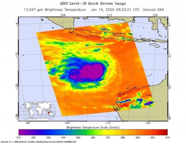
One of the ways NASA researches tropical cyclones is using infrared data that provides temperature information. The AIRS instrument aboard NASA’s Aqua satellite captured a look at those temperatures in Claudia’s cloud tops and got insight into the storm’s strength.
Cloud top temperatures provide information to forecasters about where the strongest storms are located within a tropical cyclone. Tropical cyclones do not always have uniform strength, and some sides have stronger sides than others. The stronger the storms, the higher they extend into the troposphere, and the colder the cloud temperatures.
On Jan. 14 at 1:23 EST (0623 UTC) NASA’s Aqua satellite analyzed the storm using the Atmospheric Infrared Sounder or AIRS instrument. AIRS found the coldest cloud top temperatures were getting warmer. That is an indication that the uplift of air in the storm is not as strong as it was before. AIRS found temperatures as cold as or colder than minus 63 degrees Fahrenheit (minus 53 degrees Celsius) around Claudia’s center. NASA research has shown that cloud top temperatures that cold indicate strong storms that have the capability to create heavy rain.
Read more at NASA/Goddard Space Flight Center
Image: On Jan. 14 at 1:23 EST (0623 UTC) NASA's Aqua satellite analyzed Tropical Storm Claudia using the Atmospheric Infrared Sounder or AIRS instrument. AIRS found coldest cloud top temperatures as cold as or colder than (purple) minus 63 degrees Fahrenheit (minus 53 degrees Celsius) north and east of Imelda's center. (Credit: Credit: NASA JPL/Heidar Thrastarson)