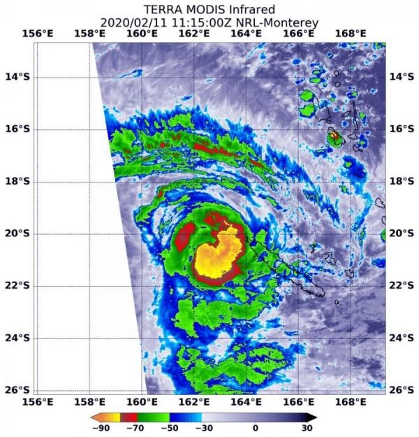
NASA’s Terra satellite passed over the South Pacific Ocean and found a stronger Tropical Cyclone Uesi after obtaining infrared imagery of the storm. Uesi continues moving away from Vanuatu and today is affecting New Caledonia.
Infrared data provides temperature information, and identifies the strongest thunderstorms that reach high into the atmosphere and have the coldest cloud top temperatures. On Feb. 11 at 6:15 a.m. EST (1115 UTC), the Moderate Resolution Imaging Spectroradiometer or MODIS instrument aboard NASA’s Terra satellite gathered that temperature information about Uesi’s cloud tops. MODIS found powerful thunderstorms south and east of the center of circulation where temperatures were as cold as or colder than minus 80 degrees Fahrenheit (minus 62.2 Celsius). Cloud top temperatures that cold indicate strong storms with the potential to generate heavy rainfall.
On Feb. 11, the Vanuatu Meteorology and Geo-Hazards Department (VMGD), in Port Vila issued an update on Uesi. At 7:48 a.m. EST (11:48 p.m. Vanuatu local time), Tropical Cyclone Uesi was located at latitude 19.6 degrees south and longitude 162.6 east, about 435 miles (700 km) west of Tanna. Winds close to the center of the system have increased from near 55 mph (90 kph/50 knots) to 78 mph (125 kph/67 knots), making it equivalent to a Category 1 hurricane. Uesi was moving in a south-southeasterly direction. VMGD said that the potential for the system to recurve and move towards Vanuatu is low.
Read more at NASA/Goddard Space Flight Center
Image: On Feb. 11 at 6:15 a.m. EST (1115 UTC), the MODIS instrument aboard NASA's Terra satellite gathered temperature information about Uesi's cloud tops. MODIS found powerful thunderstorms south and east of the center of circulation where temperatures were as cold as or colder than minus 80 degrees Fahrenheit (minus 62.2 Celsius). (Credit: NASA/NRL)


