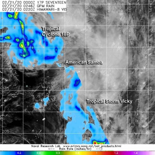
There are two tropical cyclones affecting American Samoa in the South Pacific Ocean on Feb. 21. Tropical Storm Vicky has triggered warnings, while Tropical Cyclone 18P continues to develop. The Global Precipitation Measurement mission or GPM satellite provided a look at the rainfall rates occurring in both storms.
Vicky is located to the southeast of American Samoa and 18P is located to the northwest. American Samoa is a U.S. territory covering seven islands and atolls. The capital city of Pago Pago is located on Tutuila, the largest island.
The National Weather Service (NWS) in Pago Pago issued a Tropical Storm Warning on Feb. 21 for American Samoa, and coastal waters out to 40 nautical miles including National Marine Sanctuary of American Samoa.
In addition, a High Surf Warning remains in effect that states, “Hazardous surfs of at least 20 feet, with locally higher sets, will impact coastal waters, especially west through south facing shores of all islands due to the intensification of Tropical Storm Vicky south of the islands.” A Flash Flood Watch is also in effect for all of American Samoa.
Read more at NASA/Goddard Space Flight Center
Image: The GPM's core satellite passed over the South Pacific Ocean on Feb. 20 at 10:20 p.m. EDT (0220 UTC, Feb. 21). GPM found heaviest rainfall (orange) occurring in both Tropical Cyclone 18P and Tropical Storm Vicky, falling at rates of 1 inch (25 mm) per hour. Light rain appears around those heavier rainfall areas and throughout the rest of the tropical cyclones (light blue), falling at less than 0.2 inches (less than 5 millimeters) per hour. (Credit: NASA/NRL)