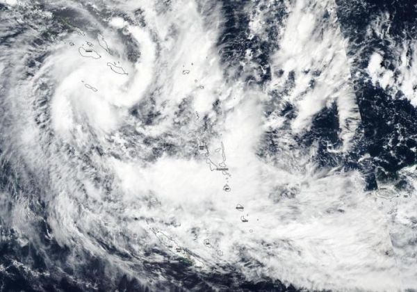
NASA-NOAA’s Suomi NPP satellite passed over the Southern Pacific Ocean and provided forecasters with a visible image of newly formed Tropical Cyclone Harold. Harold formed near the Solomon Islands and now threatens Vanuatu, which has already issued some warnings.
The Visible Infrared Imaging Radiometer Suite (VIIRS) instrument aboard Suomi NPP provided a visible image of Tropical Cyclone Harold on April 3, 2020. The VIIRS image showed the center near the Solomon Islands, with bands of thunderstorms wrapping tightly into the low-level center from the southeast and western quadrants. A long band of thunderstorms on the eastern side of the storm stretched from southeast of the center to northeast of the center. Outer fragmented bands of thunderstorms extended southeast to Vanuatu. Microwave satellite imagery has detected an eye forming.
At 1500 UTC, (10 a.m. EDT) Tropical cyclone Harold was located near latitude 13.0 degrees south and longitude 163.2 degrees east, about 429 nautical miles northwest of Port Vila, Vanuatu. Harold was moving to the south-southeast and had maximum sustained winds near 55 knots (62 mph/102 kph).
Read more at NASA/Goddard Space Flight Center
Image: NASA-NOAA's Suomi NPP satellite captured a visible image of Tropical Cyclone Harold over the Solomon Islands in the Southern Pacific Ocean on April 3, 2020. (Credit: NASA Worldview, Earth Observing System Data and Information System (EOSDIS))


