The Eastern Pacific Ocean’s hurricane season may not officially start until mid-May, but the first tropical cyclone of the season formed over the weekend of April 25 and 26. NASA’s Aqua satellite provided an infrared look at the small depression when it was at its peak and before it became post-tropical.
Tropical Depression 1E formed on Saturday, April 25 and by the next day, it was not in a favorable environment for further development, according to the National Hurricane Center (NHC). NASA’s Aqua satellite provided forecasters with a look at 1E’s cloud top temperatures to assess the strength of the storm.
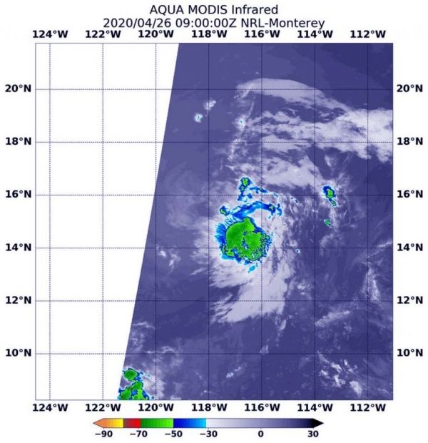
NASA’s Aqua satellite passed over Tropical Depression 1E on Sunday, April 26, 2020 at 5 a.m. EDT (0900 UTC) and the Moderate Resolution Imaging Spectroradiometer or MODIS instrument aboard analyzed 1E in infrared light. Infrared light is used to determine temperature of cloud tops in storms, and the colder the cloud top, the higher it is in the troposphere (lowest layer of the atmosphere), and the stronger the storm tends to be. MODIS found cloud top temperatures as cold as minus 50 degrees Fahrenheit in the depression, not cold enough to suggest heavy rainfall.
Read more at NASA / Goddard Space Flight Center
Image: NASA’s Aqua satellite passed over Tropical Depression 1E on Sunday, April 26, 2020 at 5 a.m. EDT (0900 UTC) and the MODIS instrument aboard analyzed 1E in infrared light to determine temperature of cloud tops in storms. MODIS found cloud top temperatures as cold as minus 50 degrees Fahrenheit in the depression, not cold enough to suggest heavy rainfall. Credit: NASA/NRL