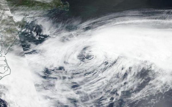
NASA-NOAA’s Suomi NPP satellite passed over the western North Atlantic Ocean and provided forecasters with a visible image of Post Tropical Storm Arthur.
During the afternoon (Eastern Daylight Time/U.S.) of May 19, the Visible Infrared Imaging Radiometer Suite (VIIRS) instrument aboard Suomi NPP provided a visible image of Arthur and showed a weak circulation with the bulk of clouds northeast and east of the center. Arthur is located out in the Western Atlantic Ocean far from the U.S. coast and parallel to the Virginia/North Carolina border.
The NOAA National Hurricane Center’s Tropical Weather Discussion on May 20 at 8:05 a.m. EDT noted, “Post-Tropical Cyclone Arthur is north of the area near latitude 35 degrees north and longitude 65 degrees west. Arthur will move southeast to south through Thursday [May 21], and weaken. Large northeastern [ocean] swell from Arthur will affect the waters that are to the NE of the Bahamas, through Friday [May 22], and then subside on Friday night and Saturday.“
Read more at NASA/Goddard Space Flight Center
Image: NASA-NOAA's Suomi NPP satellite found post tropical storm Arthur out in the Western Atlantic Ocean far from the U.S. and parallel to the Virginia/North Carolina border. (Credit: NASA Worldview, Earth Observing System Data and Information System (EOSDIS))


