NASA’s GPM core satellite analyzed rainfall generated from post-tropical cyclone Bertha as it continues to move toward the Great Lakes.
Bertha formed into a tropical storm on May 27, about 30 miles off the South Carolina coast. By 9:30 a.m. EDT, Bertha made landfall along the coast of South Carolina, east of Charleston. Data from NOAA and CORMP buoys showed that maximum sustained winds increased to near 50 mph (80 kph) before landfall. By 2 p.m. EDT, Bertha weakened to a tropical depression and heavy rainfall spread across the Carolinas. By 11 p.m. EDT, heavy rainfall spread across western North Carolina and southwest Virginia into West Virginia. At that time, the center of Bertha was located about 95 miles (150 km) south-southwest of Roanoke, Virginia. By May 28, Bertha had become a post-tropical cyclone.
A Post-Tropical Storm is a generic term for a former tropical cyclone that no longer possesses sufficient tropical characteristics to be considered a tropical cyclone. Former tropical cyclones that have become fully extratropical, subtropical, or remnant lows, are three classes of post-tropical cyclones. In any case, they no longer possess sufficient tropical characteristics to be considered a tropical cyclone. However, post-tropical cyclones can continue carrying heavy rains and high winds.
Read more at NASA/Goddard Space Flight Center
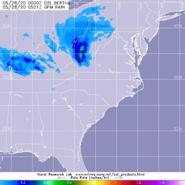
Image: The GPM’s core satellite passed over Bertha and analyzed its rainfall rates on May 28 at 1:21 a.m. EDT (0521UTC). GPM found heaviest rainfall over south central West Virginia, where rain was falling at rates of 1 inch (25 mm) per hour. A large area of light rain northwest of the center was falling at around 0.2 inches (less than 5 millimeters) per hour. Credit: NASA/NRL