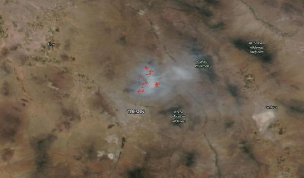
NOAA/NASA's Suomi NPP satellite captured this image of the Bush Fire on June 22, 2020 showing clouds of smoke pouring off the Bush Fire that is plaguing Arizona. Overnight (to the 23rd) the fire grew to 186,848 acres, growing 2,200 acres overnight. On June 23 the fire was 61 percent contained.
Inciweb reported that the northwest portion of the fire remains the most active. Firefighters are continued to work along the State Road 87, strengthening the fireline to secure the area. They are also continued efforts to help protect the Sunflower area. The National Weather Service (NWS) forecast calls for weather in Tucson to continue to be hot and dry with temperatures set to reach 105 degrees Fahrenheit, although winds are light which helps firefighters as they continue to battle the blaze. The NWS Discussion on June 23 said, "Hot temperatures for the remainder of the work week under high pressure aloft. The hottest days will be tomorrow and Thursday [June 25]. A few lower elevation areas could be as hot as 110 to 111 degrees both days. This is normally the hottest time of the year." United States Forest Service Wildland Fire Air Quality Response Program reported that: "Today (June 22 into June 23) will be a repeat of yesterday's weather with decreased winds and settling of smoke over rim country. Impacts should continue to improve as the fire is contained. However, unburned fuels within the perimeter continue to burn making fire and smoke possible. Brief smoke impacts may be expected through the day, however, at a lower intensity and duration from days past. Smoke will be moving predominantly from Tonto Basin North to Payson, spread East and west along Rim Country with potential impacts to Heber-Overgarrd, Show Low, Fort Apache Reservation along with the I-17 corridor north of Phoenix. The compounding of smoke from the two fires may bring moderate smoke impacts into the North and East areas of metro Phoenix."
Read more at: NASA/Goddard Space Flight Center
Bush Fire in Arizona (Photo Credit: NASA Worldview)


