NASA-NOAA’s Suomi NPP satellite imagery provided a look at the end of the second named tropical cyclone of the Eastern Pacific Ocean’s 2020 Hurricane Season.
Tropical Cyclone Boris formed in the Eastern Pacific Ocean on Wednesday, June 24 and by early on Sunday, June 29, the storm had become a remnant low-pressure area.
At NASA’s Goddard Space Flight Center in Greenbelt, Md., an animation of satellite imagery was created from NASA Worldview, Earth Observing System Data and Information System (EOSDIS). The animation used imagery from the Visible Infrared Imaging Radiometer Suite (VIIRS) instrument aboard NASA-NOAA’s Suomi NPP satellite and ran from June 26 to June 29, 2020. The animation showed the progression and weakening of Tropical Cyclone Boris as it crossed from the Eastern Pacific Ocean into the Central Pacific Ocean.
Read more at NASA / Goddard Space Flight Center
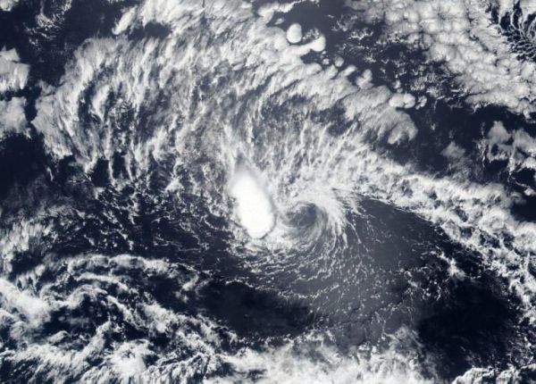
Image: NASA-NOAA’s Suomi NPP satellite provided this image of former Tropical Cyclone Boris as it weakened to a remnant low-pressure area on June 29, 2020 in the Central Pacific Ocean. The circulation center can be seen surrounded by wispy clouds with the exception of a small area of thunderstorms on the western side of the circulation. Credit: NASA Worldview, Earth Observing System Data and Information System (EOSDIS)