The number of illegal gold mines in the Amazon is increasing so fast that activists have turned to satellite imagery to identify them. Still, with thousands of new mines a year, the work was overwhelming scientists at Earthrise Alliance – they needed more hands on deck. That’s how ninth graders in Weston, Massachusetts, began locating illegal mining activity in Brazil’s protected Yanomami territory.
Earthrise is one of numerous organizations getting Earth-observation images, data, and analysis – much of which NASA makes available for free – into the hands of people working on sustainability projects. These efforts by many different aid groups are tracking illegal mining, deforestation, and groundwater resources and informing the decisions of small farmers and governments trying to support them in regions that are feeling the worst effects of climate change.
Earthrise was working with Survival International, a group that has been reporting on illegal mines in the Yanomami territory for years. Miners bring disease, like malaria and tuberculosis, which can devastate local tribes that have had little contact with people outside their communities, according to Survival International. The highly contagious novel coronavirus now also threatens the region. In addition, the mines themselves pollute the land and waterways with mercury and other toxic substances.
Read more at NASA
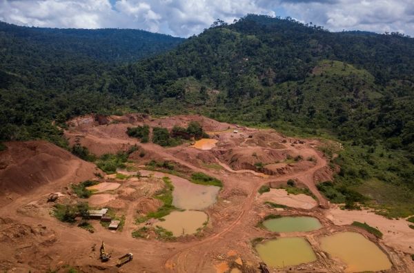
Image: A legal gold mine in Ghana shows some of the effects mining has on the landscape and environment. Illegal mines, which operate without environmental oversight, are often situated close to legal ones, and the water pools are more irregular or divert to small rivers. Ghanaian officials have shut down illegal gold mines they identified using NASA satellite data and NASA-developed analysis tools. Credits: Jordi Perdigó/Global Partnership for Sustainable Development Data