The 2020 melting season still has at least another month to gnaw away at Arctic sea ice, but it has already consumed a lot. In July, the ice cover spanning the Arctic Ocean reached a record-low extent for this time of year.
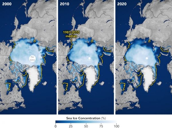
The maps above show the sea ice extent in the Arctic Ocean for July 2020 (above, right) in context with sea ice from July 2000 and 2010. Extent is defined as the total area in which the ice concentration is at least 15 percent—the minimum amount at which space-based measurements give a reliable measurement. The yellow outline on each map shows the 30-year median extent for the month.
In July 2020, the ice extent averaged 7.28 million square kilometers (2.81 million square miles), making it the lowest for July since the start of satellite measurements in 1979. The July 2020 extent is 2.19 million square kilometers below the 1981-2010 average for the month, and 310,000 square kilometers below the previous record low, set in 2019. For context, the ice extent in July 2000 was close to the 1981-2010 average, and July 2010 measured 1.4 million square kilometers below average.
Continue reading at NASA Earth Observatory
Image via NASA Earth Observatory


