Tropical Depression Omar is one stubborn storm. Since it developed early in the week, it was being affected by wind shear. That wind shear has not let up by the week’s end, and NASA satellite imagery showed the bulk of storms were being pushed to the southeast of the center. Yet, he persists.
NASA’s Aqua satellite uses infrared light to analyze the strength of storms by providing temperature information about the system’s clouds. The strongest thunderstorms that reach high into the atmosphere have the coldest cloud top temperatures.
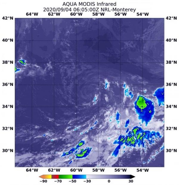
On Sept. 4 at 2:05 a.m. EDT (0605 UTC), the Moderate Resolution Imaging Spectroradiometer or MODIS instrument that flies aboard NASA’s Aqua satellite gathered infrared data on Omar that confirmed wind shear was still adversely affecting the storm. The center of circulation appears to be a swirl of clouds devoid of precipitation. In addition, satellite data reveals that some dry air is also being drawn into the circulation, which is further inhibiting the development of thunderstorms.
Read more at: NASA/Goddard Space Flight Center
On Sept. 4 at 2:05 a.m. EDT (0605 UTC), the MODIS instrument that flies aboard NASA's Aqua satellite gathered infrared data on Omar that confirmed wind shear was adversely affecting the storm. Persistent north-northwesterly vertical wind shear showed strongest storms (yellow) pushed southeast of the center where cloud top temperatures are as cold as minus 50 degrees Fahrenheit (minus 45.5 Celsius). (Photo Credit: NASA/NRL)


