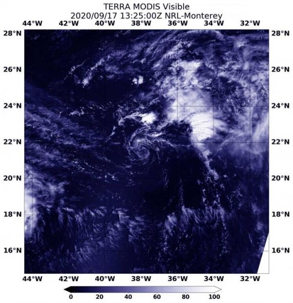
NASA’s Terra satellite found Vicky to be a shadow of its former self, devoid of precipitation around its low-level center. Any precipitation had been pushed far to the northeast from wind shear. Vicky looked like a wispy ring of clouds on visible satellite imagery and nearby Hurricane Teddy is not helping.
On Sept. 17 at 9:25 a.m. EDT (1325 UTC), the Moderate Resolution Imaging Spectroradiometer or MODIS instrument aboard NASA’s Terra satellite provided a visible image of Vicky in the eastern North Atlantic Ocean. The image showed a swirl of wispy clouds around the low-level center with the bulk of clouds pushed far to the east-northeast of the center.
Dan Brown, a Senior Hurricane Specialist at NOAA’s National Hurricane Center in Miami, Fla. noted at 11 a.m. EDT on Sept. 17, “Vicky is feeling the effects of very strong upper-level winds associated with the outflow of Hurricane Teddy. These winds have caused the remaining convection to be stripped well away from the center, and recent ASCAT (a scatterometer instrument that measures winds) data indicates that Vicky has weakened to a tropical depression.”
Read more at NASA/Goddard Space Flight Center
Image: On Sept. 17 at 9:25 a.m. EDT (1325 UTC), the MODIS instrument aboard NASA's Terra satellite provided a visible image of Vicky in the eastern North Atlantic Ocean. The image showed a swirl of wispy clouds around the low-level center with the bulk of clouds pushed far to the east-northeast of the center. (Credit: NASA/NRL)