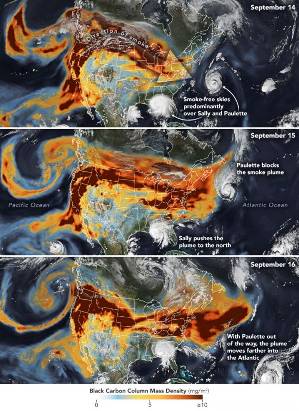
In September 2020, historic wildfires on the U.S. West Coast lofted plumes of smoke high into the atmosphere. Pushed by prevailing winds that sweep air from west to east, satellites tracked the smoke as it spread widely across much of the continental United States. A second hazard—tropical cyclones—also helped steer the high-flying smoke plumes as they streamed over the Midwest and Northeast between September 14-16, 2020.
The series of images above shows the abundance and distribution of black carbon, a type of aerosol found in wildfire smoke, as it rode jet stream winds across the United States. The black carbon data comes from the GEOS forward processing (GEOS-FP) model, which assimilates information from satellite, aircraft, and ground-based observing systems. The Visible Infrared Imaging Radiometer Suite (VIIRS) on the NOAA-NASA Suomi NPP satellite acquired the images of the storms.
As Hurricane Paulette churned in the Atlantic Ocean on September 14, the storm’s circulating winds likely helped keep the skies around the storm mostly clear. By September 15, the smoke had begun to encounter the outer edge of Paulette, whose presence helped steer smoke around the northwestern side of the storm. By September 16, the remnants of Paulette had moved northeast, closer to Newfoundland, clearing the way for the smoke plume to extend eastward unimpeded.
Continue reading at NASA Earth Observatory
Image via NASA Earth Observatory


