Hurricane Teddy has transitioned to a large post-tropical cyclone over eastern Canada. Using a NASA satellite rainfall product that incorporates data from satellites and observations, NASA estimated Teddy’s rainfall rates. In addition to the heavy rainfall, Teddy causing destructive waves and strong winds today, Sept. 23, for portions of Atlantic Canada.
Teddy made landfall in the Sheet Harbour area of Nova Scotia on the province’s Eastern Shore around 7:30 a.m. EDT, Sept. 23.
Warnings and Watches in Effect on Sept. 23
NOAA’s National Hurricane Center (NHC) issued warnings and watches for Teddy on Sept. 23. Tropical Storm Warning is in effect for the south coast of Nova Scotia from Digby to Meat Cove, and for Port aux Basques to Francois, Newfoundland, Canada.
A Tropical Storm Watch is in effect for Meat Cove to Tidnish, Nova Scotia, and from north of Digby to Fort Lawrence, Nova Scotia, and for the Magdalen Islands, Quebec and Prince Edward Island.
Read more at NASA/Goddard Space Flight Center
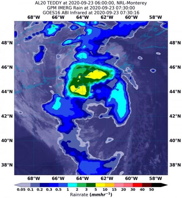
Image: NASA's IMERG rainfall product estimated on Sept. 23 at 3:30 a.m. EDT (0730 UTC) that Teddy was generating between 5 and 15 mm (0.20 and 0.60 inches) of rain per hour around the center of circulation. Rainfall throughout most of the storm was estimated as falling at a rate between 0.3 and 2 mm (0.01 to 0.08 inches) per hour. The rainfall data was overlaid on infrared imagery from NOAA's GOES-16 satellite. (Credit: NASA/NOAA/NRL)