Nearly 75% of the world’s coral reefs are under threat from global stressors such as climate change and local stressors such as overfishing and coastal development. Those working to understand and protect coral reefs are building the know-how to mitigate the damage, but doing so requires first knowing where reefs are located.
Many approaches, such as diver-based observation and satellite imagery, have been used to estimate the distribution of coral reefs around the world, but past approaches have led to inconsistent accuracy because the underlying data are derived from disparate sources and varying methodologies.
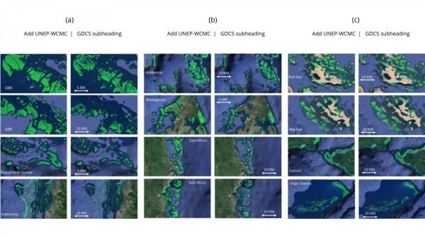
Now, researchers from the Arizona State University Center for Global Discovery and Conservation Science have generated a global coral reef extent map using a single methodology capable of predicting the location of shallow coral reefs with nearly 90% accuracy. The study was published in the journal, Coral Reefs.
The team used convolutional neural networks, an advanced artificial intelligence approach, along with thousands of satellite images from Planet Inc. to create the new global map. Planet Inc.’s satellites obtain daily coverage of the Earth’s landmass and its coral reefs at a 3.7-meter resolution. Many of these satellites are as small as a loaf of bread but, operating together, they collect over 11 terabytes of data every day.
Read more at Arizona State University
Image: Visual comparisons of a map by the United Nations Environment Program World Conservation Monitoring Centre (UNEP-WCMC), the leading global coral reef map, and the GDCS coral reef extent map in different regions, including (a) Great Barrier Reef (GBR), Australia, Papua New Guinea, Indonesia; (b) Madagascar, East Africa; (c) Red Sea, Samoa, Virgin Islands (Credit: Center for Global Discovery and Conservation Science at Arizona State University)